| |
Continents
Page history
last edited
by Mallory Burton 10 years, 2 months ago
Grade 4 Social Studies IRP:
- location of hemispheres, continents, oceans
What could be more exciting than one giant supercontinent breaking apart into individual continents?
Lots of opportunities for integrating with history, science, math studies: explorers, circumnavigation by sea and air, sizes and population of the continents, formation of volcanoes, earthquakes, mountains. Where were the dinosaurs while all this was going on and which major tectonic plate do we sit right on the edge of?
Student Link
 |
Sqworl Page for Students
Here's a link to a Sqworl page on Continents that I made for easy student access to a few of the sites below. It's very very easy to create these pages and a great way to present a selection of websites for safe research or for home use. After registering for a free account, all you do is create a new group, enter each url you want to appear on the page, give it a short title or description and Sqworl creates the thumbnails which you can drag to arrange.
|
Research
|

|
World Book Kids
WorldBook Kids has a very short introduction to continents that can be read aloud. The short article and world map can be printed. Lots of activities in the bar to the left! There's a link to WorldBook from our SD website and you don't require a password when using it at school. If students need access at home, they can ask the school librarian for the username and password.
|
|

|
Usborne Internet Linked Books
Usborne has a series of books that are excellent in print but also include many links to online sites where students can find more information or complete other activities. Your school might have (or would have to purchase) some of these, but I have several in my office if you would like to see what they look like. Here's the list of Geography titles but they have many more internet-linked books in other subject areas.
|
Online Interactive Sites/Games
 |
Interactive Map
The Houghton Mifflin site contains an interactive map that helps students learn the names of the continents and oceans by turning the names on and off in the legend. The 3 study questions on this site can be read aloud. Kids might need some direction with this site as it's not apparent what to do.
|
 |
Jet Game
In this interactive game on the Harcourt site, students answer a multiple choice question (3 choices) to fly from one continent to the next. The questions are not difficult but do require reading and an understanding of directions. Extension activity: is it possible to fly around the world in 24 hours?
|
 |
Sheppard Software Tutorial and Quiz
For more online practice, try the Sheppard Software World Continents Quizzes.
There are 4 tutorials/games about continents and oceans:
1. Tutorial: Click on the continent or ocean on the map to hear and see its name. Information about each continent or ocean is displayed on the left and can be turned off if it's distracting or too difficult for students to read. Unfortunately this information can't be read by the free NaturalReader screenreader.
2. Beginner Quiz: The program announces the name of a continent or ocean and you click on the correct continent or ocean (you can select to have only the continents or oceans in the quiz).
3. Intermediate Quiz: Drag continents and oceans to correct position on a map. Could be done by shape only as the continent and ocean names are displayed but not spoken.
4. Advanced Quiz: type the first 3 letters of the name of a continent or ocean when prompted.
|
 |
Conquer the Continents
There are many different games at Mr. Nussbaum's site including interactive maps of the world's biomes, landforms, cities, famous landmarks, names of continents, and countries within each continent.
|
 |
Pangea Interactive
Move and rotate the continents in this interactive to see how they originally fit together in the super-continent Pangea.
|
Downloadable Games
 |
Tux Typing/Spelling
Practice spelling the names of the continents and oceans with this highly popular free typing tutor. Download and install Tux Typing, select a level, and choose the continents and oceans wordlist. There is plenty of time to type the words at the "easy" level. You can also create custom word lists in Tux Typing so this would be a great way to practice other spelling words.
|
Clicker5 (requires the Clicker5 and Clicker Paint software)
 |
In this gridset, the student can learn the names of the continents and oceans. The gridset also shows the location of Canada and the oceans surrounding Canada. Students can test their knowledge using a Clicker Paint labeling task in the Practise grid. The labeling task is not self-checking.
Activity supports the Ministry of Education Learning Outcomes for Grade 4 Social Studies- Human and Physical Environment: use maps and globes to locate 1 - the world's hemispheres 2 - the world's continents and oceans. Created by Kathy Ryan.
|
Printables
 |
Quick Way to Find Outline Maps on Google
Need a quick map of the continents? Search Google, limiting your search to Images by clicking the Images Tab at the top of the page. After the search, look at the controls on the left-hand side of the page. You can choose to view only line-drawings if you want an outline map to colour or label.
|
 |
Free Downloadable Outline Maps
Free outline maps of the continents at the Eduplace site. These include a world map, a view of the northern, southern, east and west hemispheres, and the individual continents.
|
Photos/Music/Videos
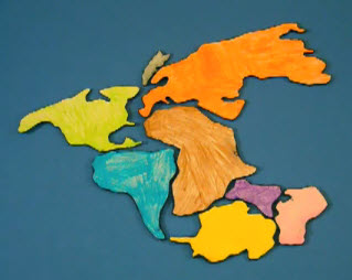 |
Breaking Apart and Coming Together
All of the Continents were once a single large continent called Pangea. Cut out the shapes of the continents and see how they fit together as a kind of puzzle and how they broke apart into their current locations. Here's how one grade 3 class portrayed the event in a video. There are many more scientific videos on You Tube but I thought kids might enjoy this one since it was made by kids.
|
 |
The Blue Marble
These NASA images of the earth from space can be used in education. There are two pictures in each set, showing the different hemispheres. Kids enjoy looking at the pictures and trying to figure out which continents they're looking at.
|
 |
Night Lights
Here's a NASA composite photo of the world at night from space. Ask students to notice where the lights are located and where the most lights are located and what that tells us about world population and wealth. Is it really possible to see all of the world at night?
|
 |
Hip Hop Anyone?
Continents and Oceans hip-hop video reviews the names of the 7 continents and 4 major oceans.
|
 |
Continents Song
Names Continents and Oceans is a simple video that introduces the names of the continents and 4 oceans using a familiar song. The catchy tune helps students remember the names but is not matched to graphics of the continents. However, students could point to the continents on a map as they sing the song. Would be a great tech project for a class to remake this video, improving it by adding the graphics.
|
 |
It's a Small World (Techno Cartoon)
Hilarious cartoon illustrations accompany a techno version of It's a Small World After All.
|
 |
It's a Small World Tour
Tour of world's famous landmarks accompanies the multilingual Disney version of It's a Small World After All. Near the end of the song, the lyrics are displayed on the screen.
|
SMARTBoard
 |
Preview and Download Free Notebook Lessons
At SMART Activity Exchange, you can preview and download several free Notebook lessons on Continents and Oceans. These activities use the tools mentioned below, so the games are already constructed for you. A search for Notebook lessons on Continents returned 126 items which you can narrow down by grade level.
|
 |
World Map and Continent Pieces
The Notebook Gallery contains a world map and matching continent shapes which can be dragged onto the map.
There's a Folder called Continents which contains the background map and all the continent shapes. Otherwise, search for "world outline" in the gallery to get the background map. Then search for each continent by name and look in the Pictures section.
|
 |
Hot Spot Continents Game
The Notebook Gallery contains a Hot Spots Activity which can be used to identify the continents and oceans.
Click Edit, select the World Map background and click Add to add the hotspots and their names. Then click OK and Start to play the game.
|
Continents
|
|
Tip: To turn text into a link, highlight the text, then click on a page or file from the list above.
|
|
|
Comments (0)
You don't have permission to comment on this page.